Vichada Project
Agricultural and extractive activities are two of the main drivers of land change worldwide. The global stock of well-located arable land is scarce, exacerbated by urbanization, infrastructure development, soil degradation, decreasing water availability and shifting agro-climatic conditions. Under this context, investment in farmland has gained importance, driven by the intersection of economic, political and environmental factors, associated with the current stage of the globalization process, an is having deep implications on local landscapes. The Colombian Eastern Plains constitute an example of this situation. It is attracting the interest of domestic and foreign investors, governments, and cooperation agencies as an opportunity for agricultural expansion and as a national and regional development strategy and important financial returns, while it allows the country to become an important player in the global agricultural commodity market. “Frontier” areas in tropical regions are being targeted as potential locations for agricultural development, backed on a narrative of economic efficiency, idling resources, rural development, low land acquisition cost and profitability that has exposed them to accelerated transformations, without considering sufficiently local specificities, resulting in increased conflicts between stakeholders, environmental degradation, loss of local livelihoods, exclusion, and displacement.
The Orinoquia project aims to understand the way the land acquisition process is carried out in the region, map and quantify the scale and rate of landscape transformation, and generate information to assess the effects it has on local communities and ecosystems, by answering to the following questions:
a) How can the transformation of land covers in the region be assessed?
b) What are the effects of land use change at the landscape level?
c) What conflicts emerge between agricultural producers and local rural communities because of changes in management practices and how do local dwellers respond to those conflicts?
d) What role does the land ownership regime play in the process and what conflicts arise from it?
Study Area
This research aims to analyze the implications of this global process for the specific conditions of the Colombian Altillanura, exploring the drivers, political and financial drivers, the actors, and
entities involved, and the effects and associated challenges.
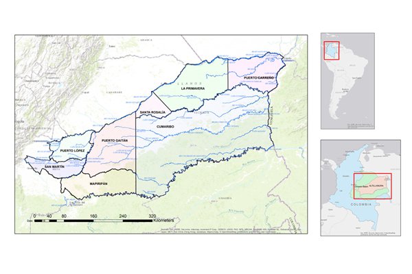
Figure 1. Study Area, Colombian Altillanura
The Colombian Orinoquia is a good example of the high ecological importance and environmental vulnerability of tropical savanna ecosystems associated with human intervention. It can be broadly described as a savanna matrix irrigated by a dense network of riparian forest ecosystems supporting most of the biodiversity and providing multiple ecological functions, and with two well defined dry and wet seasons that result in a cyclical succession of flood and fire
Starting around 2000, the region has witnessed the expansion of commodity agriculture; improved security conditions, an investor friendly framework aimed to boost capital intensive agricultural production, and ownership transfers and long term leases of public land have resulted in domestic and foreign investors establishing roughly 700,000 hectares of seasonal and perennial crops, with many more expected. Concerns about the conflicts emerging from changes in agricultural practices and differences in the demand for ecosystem services between incoming agricultural producers and traditional rural residents are rising, exacerbated by asymmetries in the access to ecosystem services caused by power relationships (Felipe-Lucia et al. 2015) Foucalt!!
A long story of migration, as a result of the armed conflict or in the search for land and new life opportunities has shaped the social composition of the region. Traditional economic activities include extensive cattle ranching, self-consumption farming and fishing, with limited impact on the local resources and ecosystem functions, while new coming actors (investors, administrators, and workers), and their practices involve intensive mechanization, and widespread application of chemicals.
These contrasting land use and ownership regimes, increased demand for water resources and the potential impacts of agrochemical use are becoming sensitive topics for communities and regional governments.
Overview
Our work aims to advance the knowledge and methods for studying complex and sensitive territories under transition to contribute to a regional economic development path that improves the local living conditions while maintaining the landscape functionalities and with limited disturbance to social relationships and tissue. We integrate remote sensing analysis with field measurements to characterize landscape transformations and effects of agricultural development and migration on the different land covers over time. Hybrid qualitative and quantitative methods are proposed to help understand people’s resource use practices, economic performance, expectations and cultural engagement with the territory. This is integrated with market data for agricultural commodities, investment flows, regulatory and institutional framework at the regional and national level, including policy milestones.